When you purchase through links on our site, we may earn an affiliate commission. This doesn’t affect our editorial independence.
You’d be surprised how much Google Maps can really do—most of us barely use half its features. Sure, it gets you from point A to point B, but there are so many extra features packed in this app that can save you time, anxiety and money. These lesser-known tools can be immensely helpful. They are useful in several ways like helping you avoid getting stuck in rush hour traffic–or making your trip seamless when exploring a new city, hitting the trails, or just trying to get directions. Here are 8 underrated Google Maps features you should start using today.
1. Download Maps for Offline Use
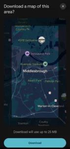
Many people have experienced that distressing moment, moving through a zone without internet service. You may try to use Google Maps but are unable to because of the absence of internet service. This could seem like a whole nightmare. But there’s a way to avoid such a trap. Just download your maps ahead of time. This could save you from panicking in the middle of nowhere. Quite easy.
How to download maps for offline use:
- Search for the specific area you want to explore.
- Once you find the area on the map, tap the name (of the area) then click the three-dot menu at the top right corner.
- Click “Download offline map.” You can adjust the area by zooming in or out.
- Once download is complete, you have a backup map that works without Wi-Fi or data.
This is a lifesaver for road trips, international travel, or anywhere with unstable internet service.

Credit: Techpolyp.com
2. Pinpoint Your Car’s Parking Spot
Have you ever frantically searched for your car in a parking lot? You look around and aren’t quite sure where you parked it. You can avoid that panic and just let Google Maps do the remembering for you.
How to save your parking spot:
- After parking, open Google Maps and tap the blue dot (the dot indicates your position).
- Click the three-dot menu → “Save parking.”
- Users can add extra notes like “My car is parked next to the statue.”
When you’re ready to leave, tap “You parked here” and get instant directions back through your entry route.

Credit: Techpolyp.com
3. Create Customized Maps
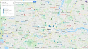
Do you know you can design your maps for your adventure without Google’s algorithm? You can create customized maps with personalised pins, routes, and notes.
How to create customized maps:
- Open Google Maps. Click “Your Places” → “Maps” → “Create Map.”
- You can measure distances on your customized map. You can also add markers and draw routes.
- Save it, and it’ll sync across all your devices.
The customized map is a feature perfect for travel enthusiasts who are planning future trips.

Credit: Techpolyp.com
4. Find Local Food & Drinks That You Desire
Google Maps isn’t just for navigation. It is also a discovery tool. It can help you find restaurants, bars, and cafes around your location.
How to find fun spots around your location using Google Maps:
- Tap “Explore” at the bottom of the app.
- Filter your selection: You can select your desired cuisine, price, ratings, etc.
- Scroll through photos, reviews, and even live busyness indicators to avoid overcrowded spots.
If you’re seeking extra adventure, you can try the “Lucky” button (available on desktop only) for a surprise/random recommendation.
Check Out Our Previous Posts:
10 Clever Ways to Use Google Lens on Your Smart Device
Google DeepMind’s AlphaEvolve: The AI Agent that Writes Codes and Invents New Algorithms
5. Measure Distances
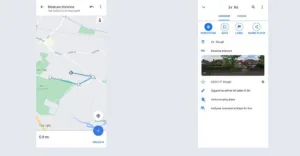
You can use this tool in Google Maps on both your computer and phone. It lets you measure distances in a straight path or along a specific route. It is quite useful for trip planning or just satisfying your random map curiosity.
How to measure distance on desktop Google Maps:
- Right-click your starting point on the map.
- Click “Measure distance.”
- Click anywhere else on the map to mark and build your path. The total distance pops up at the bottom.
- Drag points to tweak your route and see the distance update in real-time.
- If you’ve made an error, click a point to delete it. Or right-click and tap “Clear measurement” or click the “X” sign on the distance card to start fresh.
How to measure distance on mobile:
- Tap and hold your starting spot until a red pin shows up, then select “Measure distance.”
- Move the pin to your next stop and tap “Add point.”
- The distance updates as you go—keep adding points for longer routes.
- If you need to correct something, just tap a point to remove it, or just click the “X” sign to clear out the information entered.

Credit: Techpolyp.com
6. Avoid Traffic
Google Maps collaborates with authorities in your locality to incorporate official traffic information. This traffic information helps in route planning. Its machine learning algorithms analyse traffic patterns. It then uses the data to predict future traffic conditions. With its worldwide coverage, users can plan routes anywhere in the world.
How to check live traffic on Google Maps:
- Tap the layered squares icon (top right).
- Select “Traffic” and watch out for colour-coded roads:
- The green color indicates a smooth road without traffic.
- The orange color means there could be mild traffic.
- Red color means there
Note: You can set departure/arrival times in “Directions” to see traffic predictions for future trips.
7. Navigate Inside Buildings
Sometimes, large airports, malls, and mega-stores can disorient you. But Google Maps has indoor maps to help you navigate the interior of these buildings.
How to navigate inside buildings on Google Maps:
- Zoom in on the building.
- Use the floor selector (left side) to switch levels.
- Some locations offer 360° interior views. You can search for the building on Google Maps and look for the photosphere icon.
8. Share Your Real-Time Location
This feature is not so hidden, but it’s underused. You can share your live location with friends/family.
How to share live location on Google Maps:
- Tap the blue dot (your location) → “Share location.”
- Choose a contact and duration (1 hour, all day, etc.).
Live location sharing is a great feature for helping people meet up at large gatherings or just to ensure your date isn’t lying about “being on the way.”
Google Maps is more than just a GPS. It is a multi-tool for real-life problems. Using these ‘hidden’ features can make your life easier.


